Contents
An Australian east coast low is an extra-tropical cyclone that develop between 25˚ south and 40˚ south and within 5˚ of the Australian coastline. These storms mostly affect the south-eastern coast of Australia, unlike the Australian region tropical cyclones which typically have the most impact on northern Australia.
An especially intense Australia east coast low behave more similar to a tropical cyclone than an extratropical one, and before meteorologists started using satellite imagery in the 1960s many of these cyclones were identified as tropical ones.
When?
Australian east coast lows typically develop during the Australian winter season.
Where?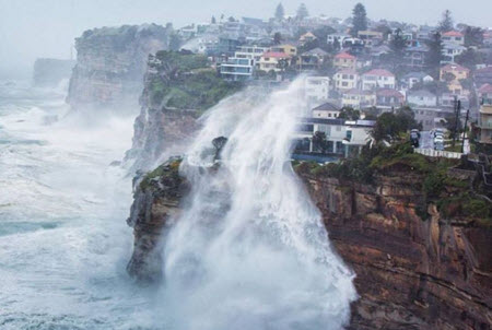
Most of these cyclones occur along the subtropical east coast of Australia, from Gladstone in Queensland to the Victoria-New South Wales border area. This stretch is home to several heavily populated urban areas, including Sydney and Brisbane.
Characteristics
Size
Australian east coast lows vary in size from from mesoscale (circa 10 km–100 km) to synoptic scale (circa 100 km–1,000 km).
Rain
Australian east coast lows tend to cause a lot of heavy and widespread rainfall.
Frequency
The number of Australian east coast low events vary from one year to another, and in some years there are no events at all. The busiest season so far was 1978-1979 when there were twelve events.
Clusters are not uncommon. Statistics from Brisbane does for instance show that nearly one third of all events here occur within 20 days of previous event.
Examples of Australian east coast low events
| When? | Info |
| 20 August
1857 |
The full-rigged ship Dunbar was wrecked off South Head while on its way to seek shelter in Sydney Harbour. Of the 122 people onboard only one survived, the crew member James Johnson who had been thrown against the cliffs at the collision and was found alive two days later. |
| June 1950 | Sydney broke its monthly rainfall record by receiving more than 642 millimeters of rain in June 1950. The heavy rains were brought by a series of east coast lows that developed off New South Wales. |
| 5 August
1986 |
Sydney’s Observatory Hill recorded 327.9 mm of rain during a 24 hour period, a record-breaking amount for that location. |
| 30-31 August
1996 |
Two fatalities
Nearly 20 million AUD in damages Wind gusts of 119 km/h (74 mph) recorded at Wollongong |
| 7-8 December
1998 |
The Sydney to Hobart Yacht Race cyclone caused the death of six race participants (five drowned and one died of a heart attack). 55 sailors were rescued in Australia’s the largest peacetime search and rescue effort, which involved 27 Royal Australian Navy vessels and 35 military and civilian aircraft. |
| 8-10 June
2007 |
The June 2007 Hunter Region and Central Coast storms caused extensive flooding and the loss of ten lives.
Insurance claims amounted to circa 1.4 billion AUD. The strongest recorded wind gusts were 135 km/h (84 mph) at Norah Head and 124 km/h (77 mph) at Newcastle. |
| 14 October
2014 |
Wind gusts exceeding 160 km/h recorded in New South Wales.
94 mm of rain fell in Strathfield in just three hours. Sydney Airport closed due to high winds. 8+ meter waves reported from Sydney. The cargoship Kiel Express broke free in Port Botany because of the strong winds. 30,000 people lost electricity |
| 20-23 April
2015 |
Severe flooding in Maitland and Dungog. Power and water access restricted for tens of thousands of people in the Hunter Region.
At least four fatalities. |
| 28 April – 1 May
2015 |
Very heavy rainfall and strong winds in southeastern Queensland and northern New South Wales. Five fatalities in the Caboolture area. |
| 5-6 June
2016 |
Severe coastal damage to Collaroy and Coogee in New South Wales when a an Australian east coast low event was combined with a King tide. Eventually, Tasmania was flooded as well. |