Contents
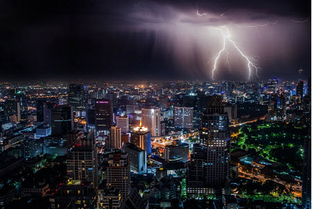
A storm characterized by the presence of lightning is known as a thunderstorm. Alternative names are lightning storm and electrical storm. Thunder is the lightnings acoustic effect, i.e. the sound produced by lightning traveling through the atmosphere.
Thunder and lightning is often, but not always, accompanied by heavy rain and strong winds. Snow, hail or ice pellets can also occur, or no precipitation at all.
Thunderstorms form when warm and moist air is rapidly moved upward. As the warm air moves upward it cools down and the moist condenses, forming a cumulonimbus cloud. When the dew point temperature is reached, water vapor turns into water droplets or ice, causing a locally reduced pressure within the thunderstorm cell. Precipitation falls through the cloud towards the earth, and when droplets collide with each other, they merge and form bigger drops. Eventually, a downdraft is created that pulls cold air with it. The strong winds commonly associated with thunderstorms is this cold air spreading out at the Earth’s surface.
All thunderstorms go through three stages: developing stage, mature stage and dissipation stage. You can read more about these stages farther down on this page. Normally, each of these stages will last for around half an hour.
There are four types of thunderstorms: single-cell, multi-cell cluster, multi-cell lines, and supercells.
Where?
Thunderstorms are especially frequent within the mid-latitudes, i.e. from 23°26’22” and 66°33’39” north, and between 23°26’22” and 66°33’39” south. Thunderstorms are more likely to form in the mid-latitudes since this is where warm, moist air from the tropics collide with cooler air from the polar regions.
Cumulonimbus
 The type of cloud associated with lightning is called cumulonimbus, but not all clouds of this type produce lightning. Cumulonimbus clouds are dense, towering and vertical. They are formed by water vapor carried by strong upward air currents.
Cumulonimbus clouds are known to form alone, in clusters and along cold front squall lines. They have their origin in overdeveloped cumulus congestus clouds
In addition to being associated with thunder, cumulonimbus clouds are also capable of producing tornadoes if conditions are right.
The name cumulonimbus is formed from the Latin words cumulus (heaped) and nimbus (rainstorm).
Formation of a thunderstorm
Developing stage (Cumulus stage)
- Masses of moisture is lifted upwards in the atmosphere. This can be caused by various forces, such as solar illumination, two winds converging, or a wind blowing over terrain where the elevation is increasing.
- As the moisture gets higher, it cools down, and eventually condense to form drops of water. This is how the cumulus cloud forms.
- When moisture condenses, latent heat is released. This makes the surrounding air warmer, which means that it also becomes less dense than the surrounding air. The warmed air rises upwards through the process of convection.
- The rising of the air creates a low-pressure zone.
Mature stage
- The warmed air continues to rise upwards.
- The warmed air reaches an area of even warmer air, causing it to stop its ascent. (This warmer air is often the troposphere.)
- Since the air can no longer continue to rise, it begins to spread out instead. Have you ever seen a thundercloud looking like an anvil? This shape is created by air spreading out. A cumulonimbus incus cloud is formed. Incus is the Latin word for anvil.
- As water droplets collide with each other, they merge and form larger droplets.
- The droplets freeze.
- The frozen droplets fall towards the earth. As they fall, they melt. This will typically result in rain, but not always. If the updraft is really strong, the frozen droplets can become so large that they don’t have time to melt completely before they reach the earth’s surface. This is what we call hail.
- The falling rain or hail drags surrounding air down with them. Updrafts are still present in the cloud, but now downdrafts are formed as well. It is this presence of both updrafts and downdrafts that produces the cumulonimbus cloud. The internal turbulence within the cloud can result in lightnings and very strong winds.
- What happens next will depend on the circumstances. If there isn’t much wind shear, the thunderstorm will normally enter the dissipating stage now (see below) and eventually dissolve. If there is sufficient wind shear however, a supercell can form instead. A supercell is a thunderstorm with a deep, persistently rotating updraft. Supercells are often isolated and can sustain themselves for several hours. Supercells are the least common type of thunderstorm, and have the potential to be the most severe.
Dissipating stage
- Above, we explained how a mature stage thunderstorm have both updrafts and downdrafts. When the downdrafts eventually take over and come to dominate the cloud, the thunderstorm has left the mature stage and is now in the dissipating stage. It is unusual for a mature thunderstorm to exist for more than 30 minutes, unless conditions favor the formation of a supercell.
- The downdrafts pushes air to the Earth’s surface where it spreads out. This is known as a downburst. The air is cool and will cut off the inflow of warm air into the cloud. The thunderstorm can no longer feed itself and starts to weaken.
During a downburst, quick and substantial changes in wind speed and wind direction can occur, making conditions precarious for aircrafts.